Thursday, September 8, 2011

No rain in sight! More fires expected!


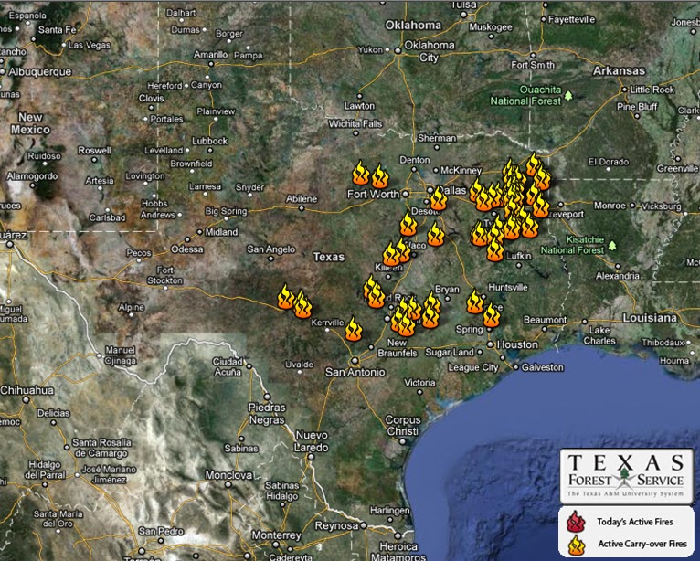
SETX Weather: First off, please pray for ones affected by the fires. Please think about how YOU can help!


Dry conditions will persist through the weekend so firefighters will not have any help from Mother Nature to battle the Texas wildfires. In fact, a northeast breeze will be expected to gust between five and 15 mph Thursday afternoon and, mixed with the dry air, could actually stoke wildfires. We have a ways to go before we emerge out of our drought and fire debacle. Winds may pick up from the north and northeast on Thursday, and with sunshine and low dewpoints it will not take much to see rapid expansion of brush and grass fires. If I believe the various computer models, we are stuck with this parched condition through at least the next eight days.

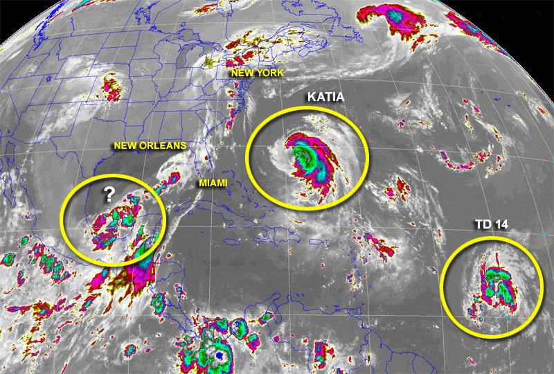
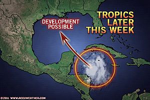
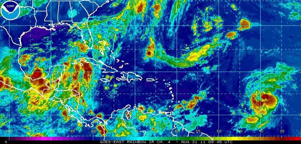
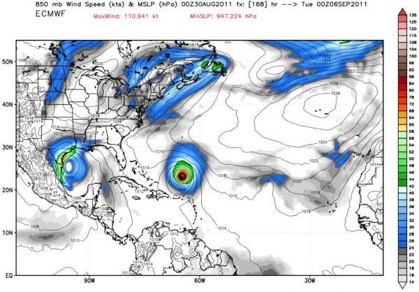
Soap box kicked aside, The cool mornings, warm afternoons and calm winds will continue Thursday gracing us with another beautiful day, but the dry conditions are sticking around as well – and boy, do we need the rain! There’s not much of a chance that either one of the three tropical developments will bring any our way. We need Nate to go to the Texas coast, but that doesn’t look like it’s going to happen. Nate is forecast to bend off to the west as a Category 1 hurricane, go inland into Mexico on Monday and not sling any rain or moisture to Texas."

Today: Sunny, with a high near 88. Northeast wind between 5 and 10 mph.
Tonight: Mostly clear, with a low around 57. East wind around 5 mph.

Wednesday, September 7, 2011

Cooler Weather Means Fire Danger! Pray for us!

Share

SETX Weather: Just about the entire state seems to be on fire! Dry conditions will persist for at least the next couple of days, but the cool mornings and calm winds will continue to aid firefighters in their battle against the Texas wildfires. It feels like a change of seasons is definitely upon us as morning temperatures kicked off delightfully cool in the upper-50s and highs are expected to top off in the upper-80s. The winds, which were a major problem for firefighters battling the wildfires over the weekend, will remain calm for most of the day, with a northeastern breeze peaking at eight to 12 miles per hour around 5 p.m., but that will settle down quickly. The extended forecast shows lows will be in the upper-50s Thursday and Friday, then increase to the lower-60s this weekend. Highs will remain in the lower-90s through Sunday.

Even though we’ve had to place our main focus on the drought and the Texas wildfires this week, we are still monitoring the tropics. Something is trying to brew out in the southern Gulf, but a dome of high pressure will -- once again -- block Texas from getting any activity. "A front that pushed through into the Gulf has stalled out and it’s quite common this time of year for low pressure to form on old fronts and it looks like this wants to develop. In fact, a lot of computer models turn this into a hurricane. "However, none of the models take it toward Texas and they race it off toward the Louisiana/ Mississippi coast or shove it south into Mexico."


As usual, these are early-model predictions so we will be watching it carefully.

Tuesday, September 6, 2011

Coolest Weather Since May Arrives in Texas!!

Share

This week, amazingly, will see cool nights. Not so amazingly, alas, is that both the days and nights will continue to be extremely dry. This week’s weather will be much cooler, with daytime highs around the mid 80s, rising to the upper 80s by the weekend. Overnight lows should remain in the upper 50s to mid 60s until the the weekend, when ...they’re forecast to rise into the low to mid 70s.


Wildfires: Importantly for wildfires near Houston and near Austin, the strong winds that developed from Tropical Storm Lee this weekend have died down, and winds should remain at modest levels for most of this week. Unfortunately, there will be little relief from the skies, with dry conditions expected to persist into at least early next week. In fact, some long-range models don’t show a chance of rain returning to Houston until the weekend of Sept. 17. These fires will remain serious!


...As for now, enjoy the Fall like weather! We ALL went through HELL to see this first front!

Wednesday, August 31, 2011

Watching the gulf this weekend....

Share

The heat advisory has been canceled Wednesday and rain is on the way! It will be another HOT day ahead, but we are getting very close to the "cooler" weather beginning Thursday!

 
Today: Mostly sunny and hot, with a high near 99. Heat index values as high as 102. Southwest wind 5 to 10 mph becoming southeast.


Moisture out in the Gulf is moving in, so the chances for rain will increase as the week comes to an end. Katia is expected to strengthen into a hurricane later today, but a tropical wave currently moving through the northwestern Caribbean could pose a more immediate threat to the United States.There is a possibility that more than just tropical moisture flows into Texas in the upcoming days. We could be looking at tropical storm formation in the central or western Gulf of Mexico.

The tropical wave in question is rather disorganized at this time, but there is room for development late in the week and into the weekend. Where the future tropical system will head after developing is not set in stone, but a track into Texas is possible. The tropics may yet lend a hand in the Texas drought situation if the tropical wave rolling through the northwestern Caribbean eventually lands in Texas.

The seriousness of the drought and heat in Texas goes without saying, and most of Texas would be willing to take a hit from a tropical storm or minimal hurricane to bring a change. However, there's a general saying, "Droughts often end with floods." With big weather often the case in Texas, the Lone Star State is no exception to this saying. The reason for this is that it simply takes a strong weather system or major pattern change to end a drought. I'm not going to say either is definitely coming to parts of Texas at this point, but there will be a disturbance milling around in the western or central Gulf of Mexico during the second half of this week.

...Enjoy (I think) mdm

Tuesday, August 30, 2011

Two more days of heat, and then we watch the Gulf!


Another hot one today as highs climb near 100 again. There will be a few clouds around with a light Southeast wind. But, after these next two days, we will be getting quite a suprise! Rain...rain...and MORE rain!
Later this week and through the weekend looks wet. Could see several inches of badly-needed rainfall. It all depends on what develops from a big slug of moisture making its way north from the Caribbean. Computer models try to develop a tropical depression or even a weak tropical storm in the Gulf by this weekend. We will be watching it close the next couple of days. Temperatures this weekend may not get out of the seventies if we see the kind of rainfall that model-data is forecasting.


First REAL cold front is forecasted to arrive next late Monday into Tuesday. I honestly believe this cold front will end our century mark temps for the rest of the year! We might come close, but I honestly think after today and tomorrow, we're done! I don't know about you, but I thought I would never see the day! Wow...Rain, tropical system and a cold front all in one weekend! Could'nt have asked for anything better! ....enjoy!


Today: Sunny and hot, with a high near 97. Heat index values as high as 101. North wind 5 to 10 mph becoming south.
Tonight: Clear, with a low around 76. South wind between 5 and 10 mph becoming calm.